Panorama of the West Bank
the street view photographic archive is produced through a moving photographic apparatus. Therefore, the documentation is twofold; first capturing the surrounding landscape to which the google car’s body is invisible—this part is the main goal of the google car photographic mission. Second, documenting the movement of the google car itself which is somehow rudimentary in spaces of free movement since the google car covers all possible roads and the more coverage of the urban space, the less visible and more concealed the capturing apparatus becomes. Thus the photographic street view archive can be looked at as an archive of movement of the google car. But why is the movement sacrificed?
FPM(Frames Per Meter)The
spatial turn in videography
The google guidelines request a 1 meter/3 feet distance between 360 images indoors and 3 meters distance outdoors. This 3 meters/10 feet distance between spherical frames, is a transformation of the frame per second FPS into a frame per meter FPM Of the street view videography. Reorienting the spherical frames from a temporal relation into a spatial relation is what constitutes an image topology which can be stitched/positioned on top of a cartographic layer through the GPS system. The 3 meters distance between the images is also the GPS resolution nowadays. So we can say that the frame per meter FPM as it becomes a spatial unit, it goes in tandem with the satellite resolution to become a unit for what we can call a cartographic image resolution of street view.
So in other words the suspension of temporality/movement is essential for the spatial positioning of such photographic archive; the positioning of videography as cartography. And at the same time such suspension is precisely what hides the orientation of the google car as a moving body. This spatial turn in the suspended videography shifts the orientation of the archive from the moving car to what seems as a “surrounding” 360° landscape. Once the 360° images are positioned, they become emptied of their initial movement/orientation and ready to be imbued with the orientation of an imaginary body/subject that is going to take the central place of the ghostly google car/camera as it disappears.
Mahmoud Keshavarz in "Design Politics" asserts “Think of borders not as lines designed by states to protect their citizens and promote a sense of security, but as mechanism that hide battle of authority of knowing over the material reconfiguration of the act of moving, crossing and transgressing." Thus what Keshavarz calls "border working" is fundamentally urban practices of controlled mobility and segregated mobility which the google car can not escape as a moving body on the street; and it being a recording device transforms such “material reconfiguration of the act of moving” into a material reconfiguration of the act of imaging. What seems to be an act of regulation and obstruction of images, ends up being images of acts of regulation and obstruction.
How to measure a contemporary occupation with a google car?
In order for cinematic frames to lend you their gaze, to let you look and think through them; there is a sacrifice that needs to take place. That chunk of spacetime that is piled at the back of the frame in order for you to look somewhere and not somewhere else. This chunk of spacetime and not that chunk. As Eisenstein had said out of the conflict between a director’s gaze and a photographed object that the frame is framed. This is the conflict that you are going to look through; to think through, that will lend you its movement, its spacetime. A 360 frame is initially a paradox to such cinematic logic. One of the main questions of the soviet 360 cinema was: where does the director hide within a 360 frame?
as The cinematic conflict of the traditional frame gets neutralised by the 360 panoptic gaze; the cinematic chain of conflict shifts, the familiar cinematic elements are split into partial objects. The director is not directing anymore, it is partly directing, partly acting in plain sight. The event that the google street view image records is the apparatus and process of its own capture, of its own direction.
John rafman, in his work, navigates the tension of the subjective gaze as it hovers through the "indifferent" google street view image; a subjective agency of the photographer; an agency that constitutes a process of selection, extraction, and abduction of these photographic punctums from the darkness of the archive. But his focus on the photographic image undermines a main quality that is latent within the google archive. Which is the history of movement and the street as a recording surface. As the google photographic apparatus is mainly 9 cameras mounted on top of a moving car. The recording surface is not that of “the detached gaze of an indifferent being” but rather the gaze of a very differentiated being of movement, a car driving on a street, or a highway, one way or two way. Its cameras do act in history, they enact the politics of the streets; in the google apparatus the politics of the image is mounted on top of the politics of movement and the two are not separated from each other. The cameras as they become the streets become the material witness of geopolitics.
”nonetheless Google Street Views present a universe observed by the detached gaze of an indifferent Being. As its cameras witness but do not act in history”
excerpt from an interview with artist John Rafman
The street view visual regime is attached to the urban regime of mobility. As the photographic images of The street view get infused with geospatial metadata (geolocation, elevation, camera rotation to the north, panorama ID). They are constantly decoded as photographic objects that reference an event and recoded as cartographic tiles that fill up a Euclidian void.
This cinema is a non-human cinema, or in other words it is a domain of multiple human and non-human agencies that are arranged as a chain.The street is connected to the wheels, the wheels are connected to the steering wheel, the steering is connected to the hands of the driver, the car is connected to the camera, the camera is occupied and securitised. In this chain, the camera loses the movement agency, as it gets replaced with the movement agency of the car which is one and the same of the street. The cinematic frame is less the rectangular frame of human perception, and becomes more of the order of the urban flow, of the order of traffic. The flow of shots is an urban flow, a highway traffic. An occupation which is a struggle over land, becomes simultaneously a struggle over the image. The cinematic conflict does not disappear; it rather becomes the real conflict over movement, over territory, the conflict of occupation. The occupation as conflict becomes the cinematic agency. This research investigates the occupation as a struggle over the image, and as the cinematic agency of the street-view.
So I look at the archive of google maps as a visual archive of such regime of mobility that is propelled by the cinematic desire; one which André Bazin addresses in his essay "The myth of total cinema".This phantasy still seeps through the cartographic apparatus, and propels it towards a total imperial map; it underlays it as its undifferentiated unconscious, undifferentiated event, one that can be navigated in infinite ways. Cinema is latent as a potential, as an undifferentiated event that lost its course as it strived for totality. That lost its time as it devoured a Euclidian space. A total eye with geo-saccades, an eye that pretends to have the circumference of earth and an atmospheric cornea. It is a cinema but a different type of cinema, barely recognisable. The myth of total cinema runs through its veins, a totality of the image and an image of the total, a global image. An image that confuses itself with the globe, an eye ball that confuses itself with earth, and saccades that confuses themselves with wheels.The cinema was not in the camera’s of the elites, not waiting to unfold from a film strip. Cinema was unfolding from a deeper archaic eye that confused itself with the image it produced. A confusion and a contamination that constitutes the flow of desire. Cinema emerged from this panoramic desire of the eye. A desire that was not a succession to the eye or to seeing but the core that through which the eye closed upon itself in order to see the world.

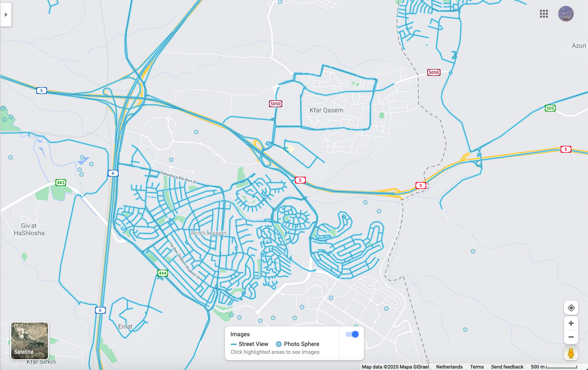
the production of such spaces of controlled mobility and asymmetrical image making through the green Mazda body in Kafr Qasem compared to the fully established image infrastructure in the neighbouring Israeli city Rosh Haayin.
27 years
documentary
to be viewed in a
speed of 100 km
per hour with a
FPM of 0,1
Qalansuwa, Tira, Jaljulia and Kafr Qasem are four Palestinian territories located outside the West Bank, meaning on the Israeli side of the green Line—1949 Armistice border. Their images on google maps is a direct articulation of this process of translation from the “material reconfiguration of the act of moving” into a material reconfiguration of the image that documents and testifies for the violence involved in its own creation.
The street view in the four Palestinian territories captured on July 2012 documents a green Mazda(Israeli yellow license)—instead of a green line—that is constantly embedded within the 360 frame, apparently leading and giving movement instructions—obstructions—to the google car. In this instance of interaction the google car becomes both the official green/red/blue/yellow/white car with a camera mounted on top and the green Mazda that gives movement cues to the former one. Going in line with Mahmoud Keshavarz in understanding borders not as localities but as a set of delocalised material practices—which he terms “border-working”—that produce spaces of immobility; one would consider the green Mazda as a part of the materialisation of the Israeli-Palestinian border and at the same time the border/frame of what is rendered visible as street view and what remains viewless.
Oct 2012
July 2012/Qalansuwa, Tira, Jaljulia and Kafr Qasem/securitised by a green Mazda

On the other hand the green Mazda inextricability from the google car—that is simultaneously a moving car and a photographic apparatus—transforms this dual object into a border that documents and frames itself. As it participates in the violence of movement, it also testifies for it. A critically designed self-documenting bordering apparatus that can transpire the politics of the street onto the street-view. What Keshavarz advocates for in “Design Politics” is counter practices of looking that can transpire the invisible border-working and reveals its hidden frames. One can situate this contingent framing apparatus as a counter practice of looking in which the frame becomes central. Such a contingent critical apparatus is not necessarily subjectively organised or officially established and designed as such but rather emerges as a contingent material configuration in the midst of a border-working chasing game.�
The mapping of most of the West Bank—which was achieved over the time period 2011-2017—is securitised/authorised through a collection of different cars, from the VIP SECURITY(Palestinian white license) car in Ramallah, Al Bireh and Bethlehem-which was a program authorised by the Palestinian Authority; to private Israeli licensed cars in Jerusalem and the rest of the West Bank. On the contrary to the carto-graphing of the green Mazda which shows only its back side —since it takes the leading role; the securitised carto-graphing shows the front side of the security cars which are following the google car throughout its journey.
Borderama
Where does the director hide within a circorama/360 frame?
The gaze of a very differentiated being/The street gaze
The myth of total cinema
November 2011/East Jerusalem/securitised by a white Suzuki SX4(Israeli yellow license)
July 2012/Qalansuwa, Tira, Jaljulia and Kafr Qasem/securitised by a green Mazda
September 2012/Israeli road network in the West Bank(road 557-57-55-60 northern to Ariel)/securitised by a dark blue Ford(Israeli yellow license)
March 2017/Ramalla, Betlehem and road in-between/securitised by a VIP SECURITY white Citroen Berlingo
October 2012/Israeli road network in the West Bank(Ariel and Southwards)/securitised by a white Suzuki Splash
why is the
movement
sacrificed?
cinematography
matters
The cameras as they become the streets ,become the material witness of geopolitics.
Border-working/image-making
The green line/Mazda
These are The walls around the Jewish enclave of Gilo which were erected in 2002 against sniper attacks from Beit Jala. Until the Israel Defense Forces (IDF) started to dismantle it in August 2010, it presented a wall gallery from the Israeli side. Gilo residents created its images at the request of the Jerusalem municipality. Some of the concrete slabs were painted over with replications of the shielded-off landscape beyond.
Rosh Haayin
Kfar Qasem
Occupation as a struggle
over the image
You can find the article by googling the phone number on the car
02-2951514